 Earth & Space
Rising Water and Sinking Land: The Ganges Delta
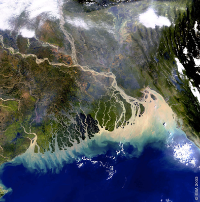
The Ganges delta, covering two-thirds of Bangladesh, is one of the most vulnerable regions in the world. It presents a challenge for climate change adaptation of nearly 200 million inhabitants. After analyzing more than a hundred water-level gauges, we found that sea-level could rise up to 140 cm by 2100, almost twice as high as previously thought and that is likely due to land subsidence.

The Ganges delta is the largest and most fertile river delta in the world, and home for nearly 200 million people. The low-lying delta plain, covering two-thirds of Bangladesh, stands less than one meter above sea level. The rising water-level in the delta is causing loss of agricultural land, salinization of the soil and migration of the local population. It is clear that climate change poses a huge risk for the delta's population, which already suffers from inadequate infrastructure, poverty and seasonal monsoonal flooding and cyclones. However, the dynamics and impact of the water-level rise at the Ganges delta is not well understood, despite its importance to the region.
Water levels in the delta are affected by a range of different factors including rainfall, river flows, sea-level rise and the sinking of the delta itself. Current estimates for changes in water levels were obtained using localized measurements, which are affected by various local processes (e.g. water pumping, sediment compaction, etc). However, we argue that understanding the relative contributions of these factors requires a broader view. In our study, we estimate regional tendencies of water-level changes driven by freshwater dynamics, vertical land motion and the sea-level rise.
To estimate the change in water level at a regional scale, we used more than a hundred local gauge measurements across the delta. We reconstructed the regional water level changes since the 1970s and showed that the rise in water-level across the delta, about ~3 millimeters per year, is lower than many estimates of local sea-level trends reported earlier (6-21 mm/year). This result is surprising, because it means that over the past 45 years, the delta did not sink as fast as previous models predicted.
Finally, by combining sea level changes measured by satellite with our water-level reconstructions, we found that the land sinking rates across the delta range between 1 and 7 mm/year over the past 20 years. Although not negligible, these values are significantly lower than ones observed locally that have been used as a reference until now (e.g. sinking rate of 10-20 mm/year in Dhaka, the capital of Bangladesh).
It is plausible that the delta continues sinking at the same pace in the nearest hundred years because it is driven by relatively slow (on the human time scale) natural processes. However, we now have the data to suggest that the sea-level rise in the delta might be worse than previously predicted, and could reach 85 to 140 cm by 2100, even under an optimist greenhouse gas scenario. This is doubling the current estimates by the Intergovernmental Panel on Climate Change (IPCC), which did not take land sinking into account.
Sea-level rise will undoubtedly impact the coastal delta in the near future. The area the most vulnerable to the consequences of sea-level rise will be the east of the delta, in Bangladesh, where more than 28 million people live in higher-risk areas today. Additionally, the moderate rates of regional subsidence rate across the delta may be further amplified due to groundwater pumping and other local factors.
Decision makers and policy makers must take these finding into account to improve climate adaptation strategies and flood disaster management.
Original Article:
1. Becker M, Papa F, Karpytchev M, et al. Water level changes, subsidence, and sea level rise in the Ganges-Brahmaputra-Meghna delta. Proc Natl Acad Sci U S A. 2020;117(4):1867-1876.
Edited by:
Dr. Ayala Sela , Associate Editor
We thought you might like
Fighting back antibiotic resistance: a new hope from the soil
Feb 24, 2016 in Microbiology | 4 min read by Dan KramerAre planets with oxygen-rich atmospheres rare?
Aug 11, 2020 in Earth & Space | 3 min read by Lewis Alcott , Benjamin MillsIs the Sun a Sun-like star?
Jun 11, 2021 in Earth & Space | 4.5 min read by Timo Reinhold , Alexander I. ShapiroHumans are affecting the evolution of animals and plants
Feb 13, 2020 in Evolution & Behaviour | 3 min read by Carine EmerMore from Earth & Space
Discovery of the first radiation belt beyond the Solar System
Jan 27, 2025 in Earth & Space | 3.5 min read by Juan Bautista Climent OliverOne million (paper) satellites
Jan 24, 2025 in Earth & Space | 3 min read by Ewan Wright , Andrew FalleVolcanic Ash: A Nutrient Boost for Reef-Building Corals
Sep 18, 2024 in Earth & Space | 4 min read by Frank Förster , Tom SheldrakeAmmonia Energy: A Call for Environmental Awareness
Aug 29, 2024 in Earth & Space | 3.5 min read by Matteo Bertagni , Robert Socolow , Amilcare PorporatoLikely increase in coral thermal tolerance at a Pacific archipelago
Dec 29, 2023 in Earth & Space | 3 min read by Liam LachsEditor's picks
Trending now
Popular topics


