
 Earth & Space
Using satellites to look for floating plastics in the ocean
Each year, millions of tons of plastic enter our oceans, adding pressure to ecosystems and threatening marine life. Observing the marine environment using satellites offer a unique ‘bird’s eye’ perspective. For the first time, we show how freely available satellite data can be used to detect plastic patches in coastal waters.
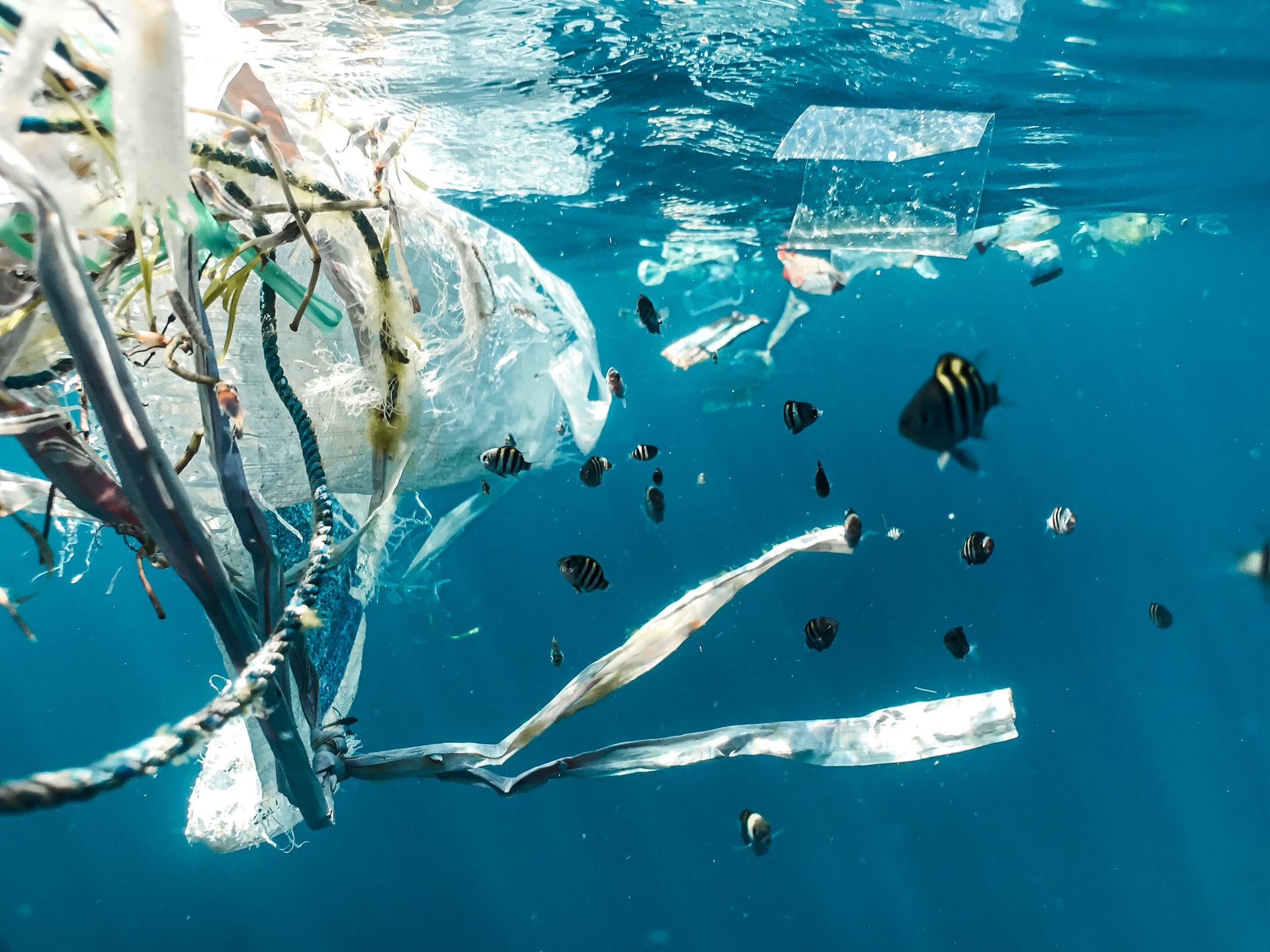
Plastics in the marine environment pose a significant threat to marine life. Macroplastics entering ocean waters have two fates - floating on the surface, or sinking. If not removed by clean-up operations, they may harm or even kill marine life through entanglement or ingestion, and/or become broken down into tiny microplastics. Though these small pieces of plastic are less of a visible source of pollution, they can enter the marine foodweb more readily, and are even more challenging to remove from the marine environment than macroplastics. Thus, being able to detect larger floating plastics in coastal waters before they become entangled, ingested or fragmented is important. Furthermore, this information may also be used to identify sources of plastic entering the ocean, and help put a stop to litter 'leakage' in the first place. This is important because the impact of plastic litter on the value (natural capital) of marine systems including tourism, recreation and fishing can cause losses in the range of $3300-$33,000 per ton of plastic per year.
High resolution imagery collected from satellites have previously been used to identify and highlight environmental problems such as deforestation and melting glaciers. In the marine context, they also have the potential to identify plastics floating on the ocean surface. However, few studies have successfully demonstrated this. The lack of previous work on detecting plastics from satellites is partly down to available technology. In order to be able to detect plastics with high confidence, data with sufficiently high spatial resolution (size of each pixel in the image) and spectral range (both visible and non-visible light) are needed. This requirement was only recently fulfilled by the Sentinel-2 Earth observation mission, which is operated by the European Space Agency. Although Sentinel-2 data fulfils the spatial and spectral requirements for identifying plastics, finding a handful of image pixels containing plastic in a scene that contains millions of pixels is not a trivial task, which this study aimed to address.
To determine what plastics look like in Sentinel-2 satellite imagery, we used large plastic targets that were deployed by the Marine Remote Sensing group at the University of the Aegean. Without these 'known floating plastics' to use as basis, our task would be like starting to look for a needle in a haystack without being certain what a needle looks like! With the targets to guide us, we developed ways of enhancing the satellite data to highlight potential patches of plastic on the surface of the ocean. We designed a 'Floating Debris Index', which uses visible (blue, red and green light) and non-visible (near-infrared to short wave infrared) bands present in Sentinel-2 data to highlight pixels containing floating materials. Combining our 'Floating Debris Index' with other information available from Sentinel-2, plus the knowledge of what plastic looks like in Sentinel-2 data, we could identify plastic in satellite images taken all over the world.
While being able to identify plastic in Sentinel-2 data is a big step forward, the initial approach has relied on someone manually looking at each image. This is time-consuming and prone to human interpretation or error. For the approach to be more reproducible for monitoring, the classification process needed to be automated. In this way, a computer can identify likely plastics, analyzing many images with highest confidence. We used a technique called 'Machine Learning', specifically a method called a Naïve Bayesian classifier, to 'train' a computer to identify pixels in an image likely to contain plastics. In addition, we also trained the computer to recognize water, seaweed, timber, foam and pumice, so pixels containing these weren't mistaken for plastic.
After training our algorithm to detect plastics and other material using data from a variety of sites, we tested it using data not included in training - to see if it could accurately classify the information. When comparing the information obtained from a computer using our Naïve Bayesian classifier with a person manually analyzing the image, we saw a high level of accuracy. Most importantly, our Naïve Bayesian classifier correctly classified as plastic all pixels corresponding to the plastic targets.
Using satellite data from Sentinel-2, we demonstrated that it is possible to detect aggregated plastic in the marine environment and separate these from other floating materials. Machine learning helped with this process by successfully and automatically classifying floating plastics from other materials.
While the approach demonstrated it is possible to use satellite data to detect plastic in the marine environment, the images used in this study only represent a fraction of data collected from Sentinel-2. Our future work will focus on making the method more robust, so it can be used on a greater proportion of data being collected. At the moment, Sentinel-2 collects data only over coastal areas so other approaches will be needed for detecting plastic in the open ocean.
Original Article:
Biermann, L., Clewley, D., Martinez-Vicente, V. & Topouzelis, K. Finding Plastic Patches in Coastal Waters using Optical Satellite Data. Sci. Rep. 10, 1-10 (2020).
Next read: A connected ocean: drifting fish larvae bind nations' marine territories by Nandini Ramesh , Kimberly L. Oremus , James A. Rising
Edited by:
Dr. Ayala Sela , Associate Editor
We thought you might like
All guts, no glory: ingested microplastics in marine mammals
Sep 11, 2019 in Earth & Space | 4 min read by Sarah NelmsMicrofibers in the ocean: are they all made of plastic?
Feb 2, 2021 in Earth & Space | 4 min read by Giuseppe SuariaPlastic is fantastic, but recycling is no magic
Apr 9, 2021 in Maths, Physics & Chemistry | 3.5 min read by Olivier A. KirchhofferMore from Earth & Space
Likely increase in coral thermal tolerance at a Pacific archipelago
Dec 29, 2023 in Earth & Space | 3 min read by Liam LachsEarth’s large lakes are shrinking
Dec 27, 2023 in Earth & Space | 3 min read by Fangfang Yao , Ben Livneh , Balaji RajagopalanGas in distant galaxies: mixed or matched?
Nov 22, 2023 in Earth & Space | 3 min read by Tanita Ramburuth-HurtThe astonishing jet of an extreme gamma-ray burst
Nov 20, 2023 in Earth & Space | 4 min read by Brendan O'ConnorOn how to use earthquakes to study a volcano
Oct 16, 2023 in Earth & Space | 4 min read by Carmen del Fresno , Simone CescaEditor's picks
Trending now
Popular topics