
 Earth & Space
How to know slow slip events and anticipate future large earthquakes
To visualize the slow slip events on the plate boundary and the geological process that leads to future catastrophic earthquakes, we installed a "seafloor GNSS station".
The technology of positioning ourselves with satellites, called GNSS (Global Navigation Satellite System) positioning, is now inseparable from our lives. If we apply high-precision analysis technology for GNSS positioning, we can see the plate tectonics at a cm/year-order speed. When this high-precision observation is performed at where the plates collide with each other, crustal deformation and a strain accumulation due to a megathrust earthquake are visible. Examining the time change more closely reveals that a slow slip event occurs at the plate boundary and slowly releases a strain. This geodetic observation is indispensable for knowing catastrophic events caused by magnitude (M) 8 ~ M9 earthquakes such as the 2004 Sumatra-Andaman earthquake and the 2011 Tohoku-oki earthquake and taking disaster-prevention measures.
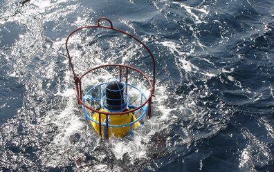
However, when the plate collision area is below the seafloor, such as offshore of the Japan Islands, it is impossible to see the strain condition by using the land-based GNSS observation network. Slow slip events that occur below the seafloor are more challenging to see. How can we make it visible? Our task has been the installation of a GNSS station on the seafloor.
GNSS communicates through a radio wave. Radio waves are scattered underwater and do not reach the deep sea. So, we used a sound wave. A sound wave reaches the deep sea 3000 m below, therefore, a sound station has been installed on the seafloor, and a ship (equipped GNSS and sound station) was placed on the corresponding sea surface. When GNSS measured the absolute position over the sea, and a sound measured a relative distance underwater, we could determine cm-level seafloor crustal deformation.
This technology is called GNSS-A ("A" means "Acoustic"). An important geodetic observation project using this technology has been performed at the nest of massive earthquakes called the Nankai Trough near the Japan Islands. This area is well known for having a huge M8 ~ M9 earthquake once every 100 ~ 200 years. It is the most critical area for earthquake disaster prevention in Japan. How is this area accumulating energy and strain for future earthquakes? What kind of slow slip events occur daily around the strain accumulating area? We tried to know them using fifteen GNSS-A stations installed on the Nankai Trough seafloor.
We first checked the average crustal deformation field for about nine years and developed the strain accumulation map. Strain accumulating areas were complementary to subducted seamounts and slow earthquakes (with slower fault slip than an earthquake) activities.
In 2020, we succeeded in detecting slow slip events signals by improving sound structure models and developing the statistical detection process. For example, we found that slow slip events repeatedly occurred off the southern coast of the Japan Islands (off the Kii Channel) and that those slow earthquakes activities were synchronized. Our observation affects many related academic fields, e.g., subduction zone sciences, slow earthquake sciences, and seafloor drilling observation, and has become the key to investigating the location and scale of future large earthquakes. It was a monumental result in geodesy. Seafloor geodesy has achieved what we had wanted to see for a long time.
Our study suggests that not only a preparation process before future earthquakes but also future slow slip events beneath the Nankai Trough will continue to be detected by the GNSS-A observations. In the future, these observations will elucidate many mysteries related to seismology and earthquake disaster prevention engineering. For example, the relationship between the slow slip events and the coupling condition, the effect on large earthquakes, the difference depending on the location, and the detailed relationship with other kinds of slow earthquakes.
The current bottleneck in the GNSS-A observation technology is the use of a ship. That means a lack of real-time and high-frequency observation (the current observation frequency is several times a year). These are barriers to understanding slow slip events and elucidating large earthquakes and subduction zones. We expect that the quickness of the announcement of results and the observation frequency will be improved with the ocean platform engineering.
Original Article:
Yokota Y, Ishikawa T. Shallow slow slip events along the Nankai Trough detected by GNSS-A. Sci Adv. 2020;6(3):eaay5786.
Next read: Genetically Reprogramming Biological Clocks: One Step Closer To The Fountain Of Youth by Joana Pereira Couto
Edited by:
Massimo Caine , Founder and Director
We thought you might like
How small warm-blooded feathered flying dinosaurs came to be
Jan 7, 2021 in Evolution & Behaviour | 3.5 min read by Enrico L. RezendeFinding Dracula’s silver bullet: the fight against a bloodthirsty fungus
Jan 16, 2019 in Microbiology | 3.5 min read by Joe HsuWhat Caribbean coasts can tell us about the future of climate change
Jan 28, 2021 in Earth & Space | 3 min read by Lucas VimpereExtreme glacier melt and climate change
Nov 10, 2020 in Earth & Space | 3 min read by Lauren J. VargoMore from Earth & Space
Likely increase in coral thermal tolerance at a Pacific archipelago
Dec 29, 2023 in Earth & Space | 3 min read by Liam LachsEarth’s large lakes are shrinking
Dec 27, 2023 in Earth & Space | 3 min read by Fangfang Yao , Ben Livneh , Balaji RajagopalanGas in distant galaxies: mixed or matched?
Nov 22, 2023 in Earth & Space | 3 min read by Tanita Ramburuth-HurtThe astonishing jet of an extreme gamma-ray burst
Nov 20, 2023 in Earth & Space | 4 min read by Brendan O'ConnorOn how to use earthquakes to study a volcano
Oct 16, 2023 in Earth & Space | 4 min read by Carmen del Fresno , Simone CescaEditor's picks
Trending now
Popular topics